Abstract: In this paper, it is presented an example from the studies whichwere executed as projects by General Directorate Of Mineral Exploration And Research (MTA) in Turkey. The aim of the project is; to prepare the inventory of geolojical heritage sites in Turkey and bring about the observance of the conservation statutes of these sites. It is purposed through the conservation to increase the number and diversity of protected areas through World Heritage Sites, European and Global Geopark Networks. In addition to the main aim of the project, also determination of methods for conservation and usage of the sites is concerned.
In this scope, some of the risks were determined and methods for conservation &usage were studied in one of the areas, namely Karapinar Potential Geopark. This area lies within the Konya Closed Basin and has an important water potential. However, the remainder of recent agricultural activities has led to excessive water usage with a consequent decrease in surface and underground water levels. Konya Basin not only has a high biodiversity since it is a closed basin but also has important geological, geomorphological, archeological and historical values. Contained within the region are Beysehir Lake National Park, Red Mountain National Park, Salt Lake Special Environmental Protection Area, 16 Important Bird Area, 6 Important Plant Area and numerous other natural sites (Bolluk Lake, Meke Lake Maar, Acıgöl Maar, Hotamış Reed Bed, Ereğli Reed Beds -Akgöl). Sink holes (Çıralı, Meyil Gölü, Kızören, Timraş, Apa) are also important source values of the area. Unfortunately, the indispensable natural areas of the basin are currently under serious threat. Unsustainable irrigation policies, misuse of the water regime, intensive agricultural activities along with industrial and urban exploitations are among the most important threats. If urgent precautions are not taken about effective and sustainable usage of the natural resources, the threat of the basin becoming a desert within the next few years is inevitable.
Various methods are suggested in support of the aim of the project that is conservation of water resources and rational usage of them such as; determination of illegal water wells and limitation of number of wells, balancing feeding and pulling of ground water, preference of irrigation with pressure (drop) method which enables the minumum water loss and effective usage of water instead of savage irrigation method, educational studies about conscious usage of water, selection of new vegetation pattern that is concordant to characteristics of the basin, creation of an understanding of the management and assessment of the area through public participation.
Consequently, as it is seen at the countries that are members of European- and Global Geopark Networks; these sites have great importance on culture, economy, tourism, research-education and sustainable local development. For this reason it is crucial to protect the geotopes which form part of geoparks, determine risk factors according to features of the area and develop methods of conservation practice for the benefit of future generations.In the beginning phase of these methods, it is necessary to inform public about this sites and try to make them conscious about conservation of these areas. Thus with the cooperation of local management and political authorities, by legal actions geological conservation should be come out as governmental policy.
Furthermore, if these areas are to meet the laws recognized at international level, it will greatly assist in preventing many difficulties from arising and simplify the transformation of classic tourism understanding.
Keywords: Geological Heritage, Geological Conservation, Geopark, Geotope, Sustainable Development, Karapınar, MTA
1. Introduction
Our country, with the effect of taking place on the Alpine-Himalaya belt, makes house ownership to the widespread traces of active and changeable periods in the geological epoch. “The Turkey’s richness in biological diversity” which is pointed out by earth scientists is definitely a natural result of various complex periods including the effect of Geological Diversity.
Turkey has also a high potential about “Natural Monument Qualified Geological Formations” commonly used as “Geological Heritage Sites” which are thought to be very important by earth scientists, need to create data for scientific studies for new generations by conservation since they also carry out open laboratory qualification. One of the main reasons for this high potential is probably being a junction of three huge continents.
Together with internationally known examples like Cappadocia, Pamukkale, Koprulu Canyon, Olympos-Beydagları, also there exist local& regional scaled ones even some of them is only seen by the people in the earth science applications like; cave systems, crater lakes, glacier structures, shore and dune structures, fossil sites, volcanic formations, folded and faulted structural components also scarce rock and mineral assemblages. With these occurrences Anatolia is almost a great scaled “Geological Park” property.
The sensitivity to “Important Geological Components Conservation” is started in 1970 in earth sciences society; at various periods it was opened to discussion, although there exist sufficient legal background it has not come to desired level. For this reason, these natural records which are natural fortune of our country since they have stories of evolutional periods of the earth have come to face with threats increasing day by day.
When the development indicator that is commonly used recently “the ratio of conservation sites to country surface area” is considered there are geological heritage sites which constitute areas as much as already conserved areas.
In the scope of “Turkey’s Geological Heritage Sites and Conservation Usage Determining Project” which is carried on by MTA General Directorate, the study area Karapinar is evaluated as second suggested Jeopark site after Mut Miocene Basin.
In the extent of the project, it is aimed to take many areas in the country that has high potential in Geotourism and Geopark studies under conservation in two years time by the help of national scaled studies.
Another basic aim of the Project executed by MTA General Directorate is generating some of the Geological Heritage Areas in conservation status and announces it as a part of the international network with a study that is parallel to Global Geopark Network executed by UNESCO.
2. Geological Heritage
Karapinar Potential Geopark site is located in Central Anatolia region in Konya city boundaries and it is 100 km away from the city centre (Figure-1).
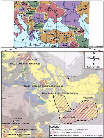
Figure-1
This area with its geological and geomorphological source values represents almost a geological laboratory property. Beside these source values it is also very rich with archeological and historical places.
The Potential Geopark site which is located at the east of Karapınar town center is evaluated in nearly 1500 km2 area as geosites, archeological and cultural sites. Geological heritage area is evaluated in two parts. First one is Obruk Plato the other one is Volcanic Garden in which there is young volcanic structures (Figure-1).
In the study area Miocene-Pliocene aged continentally formed lacustrine deposits are widespread. From bottom to the up there are conglomerate, marl, silt, fractured limestone units alternations. Upper Pliocene volcanism had brought out silicified solutions to the deposition site and formed silica nodules between clay and carbonate deposits. These units are cut by Karacadag volcanic units which are overlained by Quaternary aged Alluvium by angular unconformity.
Obruk Plato:
The area in which various structures may be seen; the most important scientific and aesthetic structures are dry and watery sinkholes.
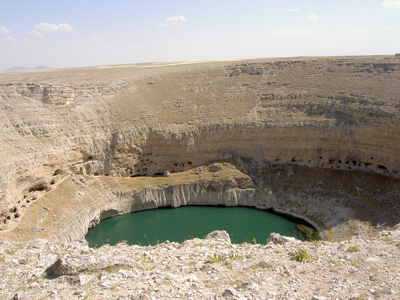
Photo-1
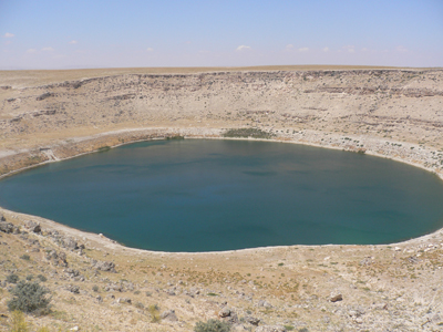
Photo-2
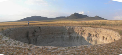
Photo-3

Photo-4
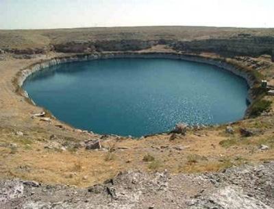
Photo-5
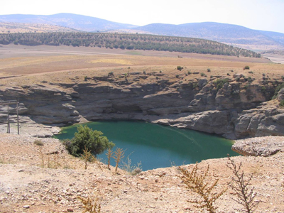
Photo-6
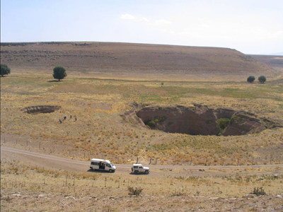
Photo-7
Konya sinkholes are developed in Neocene limestone which shows widespread distribution in the region. The sinkholes in the study area take place along a lineament which is between Cihanbeyli Traverten Cones at NW and Akgöl Ponor at SE. Amazing views and being on the linear paths make these sinkholes very attractive and since recent sinkhole developments are still continuing, it increases the importance of this area in the concept of geological heritage. At the Sinkhole Plato, except small scaled ones there are more than 20 sinkholes. Among these sinkholes 7 of them are watery and others are dry. With the measurements at the field studies it is seen that some of the sinkholes are a few meters in depth but some of them have more than 100 m depth. The best examples of these structures all of which are natural beauties are Çıralı (Photo-1), Meyil (Photo-2), Yeni Opan (Photo-3), Kızören (Photo-4),Timraş (Photo-5), Apa (Photo-6) ve May Sinkholes (Photo-7). Other than tectonics; rock types, underground water flow paths and the CO2 gas that is derived from volcanism have also effects at the sinkhole development. They are generated from the dissolving of porous limestone which has an important thickness in Pliocene aged lacustrine deposits because of underground water. The underground water that is migrating from Karapinar to north forms carbonic acid with the carbon dioxide coming from regional volcanism and this carbonic acid dissolves lacustrine limestone. This happens from depth to surface. The ceilings of the caves that are formed at depth collapse to form sinkholes. There can be seen the examples of them from development stage to mature stage. With this property the site is an open geology laboratory.
Volcanic Garden:
At the south and east pf Karapinar there are widespread young volcanic formations. In the area the tectonic path and the distribution of volcanic structures are seen to be related. Along these paths there is a sharp increase in occurrences and a distribution of volcanic shapes that follows these paths.
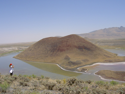
Photo-8
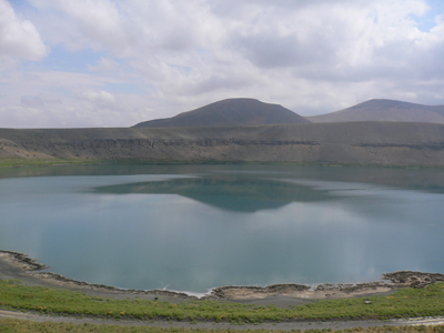
Photo-9

Photo-10
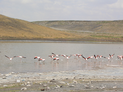
Photo-11
The area that is discussed is almost a non-vegetated area and there exist various volcanic structures that are very closer to each other and in different dimensions. With this property it reminds moon surface when examined from satellite images. The known 10 maars in Turkey, the 6 of them are situated at this area. Among these known maars, the most beautiful and popular examples are Meke Lake (Photo-8) and Acigol maars (Photo-9). Maars are depressions that are developed by volcanic explosion. On the pyroclastics that are at the walls of the maar there are typical “base surge” beds (Photo-10). At lateral stages these depressions are filled with water and lakes occurred. Both of the maars are also Ramsar area and visited by various different bird species (Photo-11).

Photo-12

Photo-13
At the volcanic garden, there exist important volcanic mountains like Karacadag, Uzecek Mountain, Meke Mountain. At the south-east of Karacadag there are NE-SW trended pyroclastic cones that are composed of basaltic lava and tuff. Around volcanic cones, the volcanic bombs which are at different shapes and dimensions are also very attractive (Photo- 12). The explosion depressions pipe shaped diatremes are also the volcanic shapes in the area. The best example of this kind is the Yılanlı Obruk at the south of Meke Maar (Photo-13).
Sand Dunes:
Dune structures that are seen near Karapinar are the other source values of the area. These are typical land shapes of the arid climates. According to the changeable climatic conditions the change of the water levels of the lakes at the Konya and Tuz Golu basins, resulted in a lithology that has a high ability to move. Parallel to this because of the corrosive effect of the wind, very rarely found Aeolian shapes were developed.(Photo-14). These are sand dunes, barchans and barchan ridges.
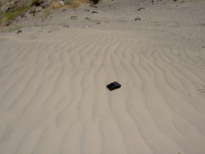
Photo-14
Travertine Cones:
One of the geosites Travertine cones are formed near Bolluk Lake around Cihanbeyli that is at north of Karapinar. There exist nearly 40 cones at different sizes (Photo-15). Bolluk Lake is also a Ramsar area and visited by various bird species.
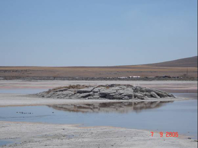
Photo-15
Archeological and Cultural Areas:
At the Karapinar suggested Geopark site which had done house ownership to many different civilization, there are also cultural, historical, archeological values. The historical remains that are found up to now from excavation studies are exhibited at the Eregli and Karaman Museums. Mammoth bones &tooth also young women mummy are the most attractive ones (Photo-16).
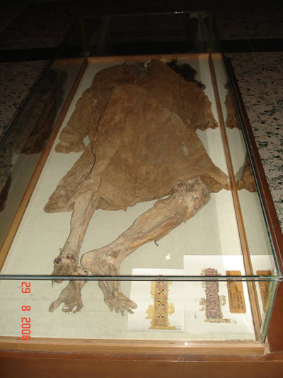
Photo-16
At the area which we thought to be very rich about under ground cities, there were found a new underground city that is very similar to the ones in Cappodocia but not opened to tourism yet. With the excavation studies done by Eregli museum there were found 12 undeground caves at the area on Karacadag which is called Oymali Underground City.
In the area there are known archeological values like Catalhoyuk but also there are a lot of tumulus which is still studying. Catalhoyuk (Photo-17) that is located in Cumra town of Konya is the most important archaeological sites of the world. Before 9000 years, at the Neolithic time it was the biggest settlement area of the world with a population of 8000. In Catalhoyuk which is 21 m, it is taught that the housing was between 900 and 1300 years.
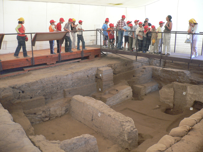
Photo-17
Ivriz Rock Relief (Photo-18) in the Eregli town belongs to B.C. 800. Richness God and praying King WARPALAWAS figures are present. The relief that belongs to Late Hittite Period was done by WARPALAWAS the king of TUWANA.
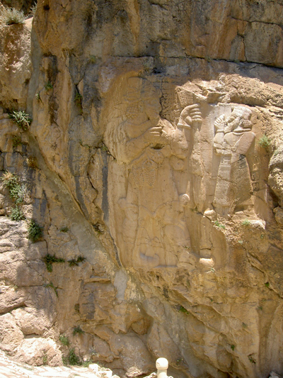
Photo-18
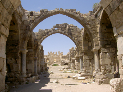
Photo-19
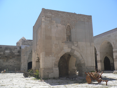
Photo-20
Obrukhan (Photo-19) which is situated at the Konya- Aksaray highway near Kızören Obruk and Sultanhanı (Photo-20) which is the biggest and the most beautiful caravanserai of the Selcuklu Empire are also historical values of the area.
3. Conservation- Usage Criterions of the Potential Geopark Area
This area lies within the Konya Closed Basin which includes Konya, Cumra, Karaman, Eregli and Karapinar plains and has an important water potential. However, the remainder of recent agricultural activities has led to excessive water usage with a consequent decrease in surface and underground water levels. Konya Basin not only has a high biodiversity since it is a closed basin but also has important geological, geomorphological, archeological and historical values. Contained within the region are Beysehir Lake National Park, Red Mountain National Park, Salt Lake Special Environmental Protection Area, 16 Important Bird Area, 6 Important Plant Area and numerous other natural sites (Bolluk Lake, Meke Lake Maar, Acıgöl Maar, Hotamış Reed Bed, Ereğli Reed Beds -Akgöl).

Photo-21
In this scope, some of the risks that the heritage area is face off were determined and methods for conservation &usage were submitted. The indispensable natural areas of the basin are currently under serious threat. The most important one of the risks is the water problem. Besides having limited evaporation also the agricultural activities give out unplanned and excess amount of water usage so that decreasing the surface &underground water levels. Because of these problems, water levels of the sinkholes including the natural beauty Meke Maar was dropped (Photo-21). Unsustainable irrigation policies, misuse of the water regime, intensive agricultural activities along with industrial and urban exploitations are among the most important threats. If urgent precautions are not taken about effective and sustainable usage of the natural resources, the threat of the basin becoming a desert within the next few years is inevitable.
Various methods are suggested in support of the aim of the project that is conservation of water resources and rational usage of them such as; determination of illegal water wells and limitation of number of wells, balancing feeding and pulling of ground water, preference of irrigation with pressure (drop) method which enables the minimum water loss and effective usage of water instead of savage irrigation method, educational studies about conscious usage of water, selection of new vegetation pattern that is concordant to characteristics of the basin, creation of an understanding of the management and assessment of the area through public participation.
Another problem is that the usage of the pyroclastic cones that are arranged among each other as quarry. Materials are taken from these cones and they are used as waste area. It is suggested to stop taking material from these cones and clean up the neighborhood of the cones.
At the region, there are underground cities and tumulus that represents a big tourism potential. However these places can not be opened to tourism since enough studies did not take place. It is suggested that, with the necessary lighting and excavation operations this area should be ready for tourism. Also new excavation studies should be done at various tumulus and be opened tourism like Catalhoyuk.
4. Conclusion
Area is suggested as a “Geological Heritage Area (Geopark) because of these properties. Opening this area to geoturism is very important for sustainable development of the public which has low income dealing with agriculture& animal husbandry and also for the region.
Also the suggested areas natural beauties are face across extinction risk. The suggestions above should be made and suitable conservation status should be given to the area. On the contrary, there is no importance of the studies about geotourism.
Consequently, as it is seen at the countries that are members of European- and Global Geopark Networks; these sites have great importance on culture, economy, tourism, research-education and sustainable local development. For this reason it is crucial to protect the geotopes which form part of geoparks, determine risk factors according to features of the area and develop methods of conservation practice for the benefit of future generations.In the beginning phase of these methods, it is necessary to inform public about this sites and try to make them conscious about conservation of these areas. Thus with the cooperation of local management and political authorities, by legal actions geological conservation should be come out as governmental policy.
Furthermore, if these areas are to meet the laws recognized at international level, it will greatly assist in preventing many difficulties from arising and simplify the transformation of classic tourism understanding.