Introduction
Karapinar is located in Central Anatolia and is a town of Konya which is the biggest city of Turkey when surface area is considered. Karapinar is established south margin of Sultaniye Plain, west of Karacadag volcanic mountain. Town is located 95 m from Konya city centre (Map 1). West of the Karapinar there is Konya and Cumra, at south Karaman and Ayranci take place, at east Eregli, at northeast Emirgazi and at north Aksaray is present. The surface area is 2669 km2. It is situated at an important highway which connects Konya to the east. The central population of the town is nearly 28.000 (1997) and with its villages total population is 44.400 (1997). Karapinar has a central location and it is very near to important city and tourism centers. In summer it is very hot and arid and in winter time it is cold & snowy that is the typical continental climate. It is one of the area in the country that has low precipitation. The average precipitation amount is approximately 280 mm. The economy is dependent on agriculture and animal husbandry. From the total town field 1.595 km2 is selected for agriculture. The industry in Karapinar is not very much developed but there is trend for developing.
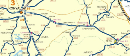
Map 1: Location map of Karapinar in Turkey.
Geotourism Potential
Karapinar and its surroundings are very important for tourism potential. Especially, Konya Mevlana Museum, Goreme National Park in Cappadocia region and Catalhoyuk in Cumra town which are very close to Karapinar, are very important tourism centers of the region.
Konya Mevlana Museum which is at one hour distance to Karapinar had been visited by 1,250,000 tourists in 2006. Mevlana Museum being a religion tourism centerhas an important role for attracting tourists in a huge range from USA to Korea. Last year with its visitor numbers, it is the most visited museum of Turkey and with this property it makes an important improvement for economy.
Another worldwide known tourism center Goreme National Park in Cappadocia is visited by 2,000,000 tourists in 2006 and it is at a two hour distance to Karapinar (Photo 1). In 1985 Cappadocia was taken to the World Heritage List and every year it has more visitors.
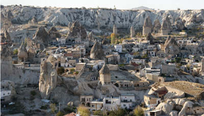
Photo 1: Cappadocia Region
Catalhoyuk which is at a 50 km distance to Karapinar is told to be one of the earliest settlement areas of the world. Catalhoyuk is important for first house architecture and first celestial structures. The visitor number in 2006 is nearly 100,000 and excavation is still continue in the area so that it is going to increase its visitor number every year (Photo 2).
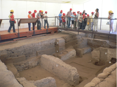
Photo 2: The young Students visiting Catalhoyuk.
It is a loss for Karapinar that although being very close to these very important tourism centers, its properties are not known sufficiently. However, Karapinar shows an attractive place property with its sand dune topography (photo 3&4) and having different kinds of volcanic structures together. If we look to the geological heritage and geotourism potential, the most beautiful monuments that are sinkholes are highly developed in this area.

Photo 3: Sand dunes generated in large scales
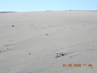
Photo 4: Sand dunes in small scale
In the formation of the sinkholes, limestone which shows very important thickness in the Pliocene lacustrine sediments is an important factor. These sinkholes with their impressive appearance and being a natural beauty must be conserved by us (Photo 5).
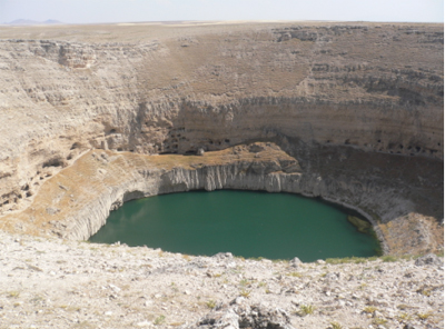
Photo 5: An example of sinkholes with water.
Apart from these sinkholes, maars that are with magnificent appearance are the other property of the area. Especially Meke Maar (Photo 6&7) is the most attractive one of the maars. It is formed million years before with a crater explosion and it is called as “Worlds Blue Bead” and also it is a bird heaven. It is determined that nearly hundred bird species are present in the region. Because of the endemic bird species, Meke Lake was estimated as natural site in 1989. However it is visited by very few visitors because of insufficient advertisement and not being a tourist site.
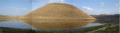
Photo 6: The magnificent view of Meke Lake.
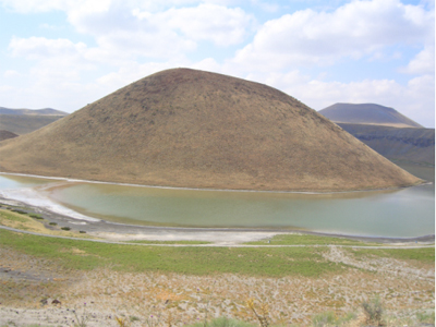
Photo 7: Meke maar
When we come to archeological part of the area, it is also very rich with this property. In the region there are a lot of underground caves, cities, tumulus and also there is the earliest agriculture monument in the area. The underground cities are very similar to the ones in Cappadocia but they are not opened to tourism yet. With the excavation studies completed in the area it is estimated that this region is very important and valuable archeological site. The possibility of new findings of underground cites is very high when we consider Oymali underground city excavation studies. It is a fact that with a sufficient environmental arrangement, lightening, ways and advertisement this region is going to be visited by a lot of people. At Karacadag, 33 underground cave is discovered and 15 of them are totally cleaned and they are waiting to be opened to tourism.
Around Karapinar belonging different geomorphologic periods, young and various original relief structures are formed. With these property site exhibits a rich potential for natural and scientific tourism. The proof is that these elements are known to be formed with different and various periods. With all of these geomorphologic elements Karapinar should be designed as an attractive geopark with scientific targets.
Conclusion and Suggestion
Karapinar region offers a potential geopark region with its closeness of popular tourism centers, natural beauties, geological properties and archeological values. For the use of these natural values in a susceptible tourism mentality, this area should be accepted as nationally and internationally geological heritage area. For carrying this potential to this region; posters that describes the area, brochures, and advertisements should be prepared festivals, symposiums should be arranged. By tourism agencies information centers should be generated and detailed information should be given by using visuals. Detailed travel routes should be determined, signboards should be placed to explain the properties of the region. This region will continue to be a focal point for researchers with geoarcheological properties, Pleistocene lake levels, climate changes and different morpho-genetical landshapes. Finally Karapinar and its surroundings will do its duty for tourism, education and scientific purposes.