Mohd Shafeea Leman1, Ibrahim Komoo1, Kamal Roslan Mohamed1, Che Aziz Ali1, Tanot Unjah1, Kasim Othman2 & Mohd Hizamri Mohd Yasin2
1 Institute for Environment and Development LESTARI, Universiti Kebangsaan Malaysia, 43600 Bangi, Selangor, MALAYSIA.
2 Forestry Department of Peninsular Malaysia, Jalan Sultan Salahudin, 50660 Kuala Lumpur, MALAYSIA.
Abstract: The Langkawi Geopark is made up of 99 tropical islands off the northwestern coast of Peninsular Malaysia covering an area of about 478 square kilometer. These rocky tropical legendary islands are rich in geodiversity, many of which have scientific value of national and regional significant. Langkawi Geopark highlights the region's most complete Palaeozoic geological history and outstanding beauty of tropical island karst landscape. The Palaeozoic rocks of Langkawi Geopark contain among others the oldest strata in the region, complete Palaeozoic succession from Cambrian to Permian, and best sedimentological and palaeontological evidences affiliating Langkawi and the surrounding region with Gondwanaland. Langkawi Geopark portrays a rich mixtures of surface water, ground water and ocean wave originated karstic landscape including some rare formation of islands and hills, ridges and pinnacles; gorges, wangs and doline lakes; caves, tunnels and their diverse cave deposit landforms; and sea-notches, sea-caves, sea-tunnels, sea-arches and sea-stacks. Langkawi Geopark geoheritage sites are mostly protected within the Malaysian holistic nature conservation concept of Geoforest Park where rock conservation is equally treated as biological conservation and other nature conservation components. Three geoforest parks of Langkawi are the Machinchang Cambrian, Kilim Karst and Dayang Bunting Marble Geoforest Parks, each of which highlighting its own unique geology and geological landscape. Other smaller conservation areas are the Recreational Forest and State Permanent Forest Reserves, which hosted several protected geoheritage sites and geological monuments outside the geoforest parks.
Keyword: geoheritage site, Palaeozoic geological history, tropical island karst, geoforest park, Recreational Forest, Langkawi, Malaysia
INTRODUCTION
Langkawi Geopark is Malaysia's and Southeast Asia's first established geopark located in the far northwestern corner of Peninsular Malaysia, adjacent to the Thai border (Figure 1). Located in the State of Kedah, the Langkawi Geopark is unique as it comprises 99 islands that formed the legendary Langkawi Archipelago. The total land area of Langkawi Geopark is about 478 square kilometers. This geopark is accessible by sea from Kuala Perlis, Kuala Kedah and Penang Ferry Terminals and by air from Kuala Lumpur, Penang, Singapore and several other International Airports.
Upon approaching the islands, via sea or air, one would be mesmerized by the beauty of Langkawi's highly diverse scenic and colourful natural landscapes. These natural landscapes often reflect diverse geodiversity and complex geological history of the islands. In a country that is largely affected by intense tropical weathering, the abundance of geological exposures and landscapes should be regarded as a rare blessing. Apart from it's rich geodiversity, Langkawi also blessed with rich flora and fauna, and diverse local cultures. These have made Langkawi one of the leading ecotourism hub in the region. With strong support from the Malaysian Federal and Kedah State Governments, the Langkawi Development Authority (LADA) has placed much effort to make Langkawi an environmentally sustainable tourist destination capitalizing on its wealth of nature diversity and recreational potential. The realization of Langkawi Geopark on 31st May 2006 is a testimony to this effort and now Langkawi should progress further to claim its stake as premier ecotourism destination in this part of the world.
GEOLOGY OF LANGKAWI
The geology of Langkawi islands today is a result of a very long depositional history under the various sedimentological regimes and palaeoenvironmental conditions, followed by the tectonic and magmatic events and finally by surface processes that etched the present beautiful landscape. The early episode of Langkawi formation was related to the long depositional events that took place along the margin of Gondwanaland. During the Palaeozoic and Mesozoic eras, Langkawi undergone dynamic geological events, most of which corresponds to events that lead towards the Gondwana dispersion and Asian accretion.
In general, rocks of Langkawi Islands can be easily divided into four sedimentary rock formations and one granite formation (Figure 2). These sedimentary rock formations, in ascending order, are the Machinchang, Setul, Singa and Chuping Formations. Langkawi sedimentary sequence is generally younging to the east, but the sequence was interrupted by the presence of Kisap Thrust Fault in the eastern part of Langkawi. The westward transport direction of this fault has brought older Setul (and possibly Machinchang) Formation(s) from the east to overlay younger Chuping and Singa Formation in the central axis of Langkawi Islands. Triassic Gunung Raya granite intruded older sedimentary rock formations and turned them partially into various types of contact metamorphic rocks. Spatial distribution of all Langkawi rock formations is shown in Figure 2 and the cross-section across Langkawi Islands is shown Figure 3.
Since Late Trisassic time, not much geological records are known for Langkawi. Tropical weathering upon rocks of Langkawi might have taken place since Early Jurassic and continues until the present day. This weathering process played very important role in producing beautiful landscapes of Langkawi today. Of special interest is the prolonged weathering on limestone and marble landscape that involved erosion and dissolution by surface, underground as well as sea water. As a result, Langkawi has one of the most beautiful and unique island karst landscapes and karst features. The world's rare mangrove on limestone bedrocks and human dependency on the mangrove environment make Langkawi Geopark even more unique. Youngest geological unit in Langkawi is the unconsolidated recent sand and clay deposited in narrow valleys and coastal plains.
Machinchang Formation (Early to Late Cambrian)
The Machinchang Formation is the oldest rock formation in Langkawi Island and in Malaysia, named by Jones (1961) after the Machinchang Mountains in the northwest of Langkawi Island (Figure 2). The Late Cambrian age for the upper part of the formation was interpreted from the presence of the country's oldest fossil fauna of brachiopod and trilobites described by Leman (1997) from Pulau Jemuruk. The Machinchang Formation is predominantly made of fine- to medium-grained sandstone with subordinate coarse-grained sandstone, conglomerate and shale accumulating a total thickness of up to 2830m. The Machinchang sandstone was interpreted as a deltaic deposit by Jones (1981), deltaic to shallow marine deposit by Lee (1983, 2006) and fluvial to deltaic and open marine deposit by Abdullah et al (1997). The formation is probably equivalent to the Tarutao Formation of South Thailand (Lee 1983) and is overlain conformably by the Setul Formation at Teluk Kubang Badak.
Setul Formation (Early Ordovician to Middle Devonian)
The Setul Formation is the oldest limestone formation in Malaysia and the neighbouring region. It is widely distributed in the eastern part of Langkawi Islands as well as in Perlis State and Satun Province of Thailand. The Setul formation was named by Jones (1961) after the Satun Province in Southern Thai for which the local Malaysian called Setul. The age of the Setul Formation ranges from Early Ordovician to Middle Devonian, interpreted from the age of various fossil horizons within the formation. The lower boundary of the formation is exposed at Teluk Kubang Badak while the upper boundary can be seen in the north Pulau Langgun, where it was overlain by the Late Devonian redbed of Singa Formation. Setul Formation is predominantly made up of thin to thickly bedded dark grey limestone, with several interfingering bands of detrital rocks. Jones (1981) described four members of the formation namely the Lower Limestone Member, Lower Detrital Member, Upper Limestone Member and the Upper Detrital Member at Langgun Island.
Singa Formation
The Singa Formation was named by Jones (1961) after the Pulau Singa Besar for the predominantly dark coloured shale and siltstone widely distributed in the southwestern part of the Langkawi Islands. The total thickness of the formation is estimated at 2100m. Its lower boundary is conformably overlain the Setul Formation in the northern part of Pulau Langgun while its upper boundaries at Pulau Singa Besar and Pulau Singa Kechil are conformably overlain by the Chuping limestone. The age of the Singa Formation is Late Devonian to late Early Permian. The Singa Formation contains various horizons of glacial marine diamictites (Stauffer & Mantajit 1981, Stauffer & Lee 1986, Leman 2000) represented by thickly bedded to massive dark gray to black siltstone and mudstone, containing sporadic clasts of various origin, size, shape and degree of roundness including a foreign one billion years old igneous rock tronjehmite. The formation also yields various horizons of coldwater brachiopod fauna (Shi et al. 1987, Leman 2003a). The Singa Formation can be divided into four members i.e. the Rebak, Kentut, Ular and Selang members, from oldest to youngest.
Chuping Formation
The Chuping Formation was named by Jones (1961) after the Chuping Hill in Perlis State for the thickly bedded to massive light gray crystalline dolomitic limestone exposed in Perlis and Langkawi Islands (Figure 2). In Langkawi Islands, however, a significant portion of the formation is composed of thinly bedded dark gray bioclastic limestone, particularly in the lower part of the formation (Leman 2003b). The total thickness of the Chuping Formation in Langkawi islands is estimated at 750-900m. The age of the formation is late Early Permian to possibly late Triassic, but only Early to Middle Permian fossils are known in Langkawi Islands. The entire upper half of the formation had undergone a certain degree of metamorphism and is therefore devoid of fossils. The basal part of the formation shows transitional passage bed between siltstone of Singa Formation to limestone bed of Setul Formation. The upper boundary of the Chuping Formation is not exposed or faulted and overthrusrted by older Setul Formation.
Granite
Large and small igneous stocks and bosses are found scattered, particularly in the central part of Langkawi Islands. Out of these there are two larger igneous stocks namely the Gunung Raya and Bukit Sawar stocks. Other bodies including the Kuah, Tuba and Dayang Bunting stocks are comparatively smaller than these two. The Langkawi igneous bodies have been collectively named as the Gunung Raya Granite, which has been dated by Bignell & Snelling (1977) as Late Triassic. Granites of Langkawi are predominantly made of porphyritic granites with some coarse- and fine-grained equigranular granites and rare dyke- and sill- forming pegmatite and aplite. The granites of Langkawi intrude several types of host rocks, transformed them into various types of metamorphic rocks, and bringing along with them some minerals such as tourmaline, ilmenite, zircon and garnet.
GEOHERITAGE OF LANGKAWI
Langkawi possesses rich geodiversity in terms of rocks, minerals, fossils, geological structures, geomorphological and landscape features, with heritage value of national and regional significant. Geoheritage of Langkawi mostly occurred within rocky coasts, cliffs, peaks and waterfalls as well as in caves. Some highly significant exposures have been classified as geoheritage sites, containing one or more geodiversities of high heritage value. There are more than 90 geoheritage sites identified throughout the Langkawi Geopark, some of which have been proposed into the National Geological Heritage Lists. Despite of its rich geodiversity, Langkawi Geopark will only highlight two major geological attractions, that are:
complete Palaeozoic geological records (Figure 4), incorporating oldest rocks and fossils in the region, best preserved sedimentary structures and fossils, best sedimentological and palaeontological evidences for affiliation with Gondwanaland.
most beautiful island karst landscape in the region featuring unique hills, ridges, islands and pinnacles, beautiful caves, tunnels and arches and the magnificent rare mangrove association with limestone bedrock.
GEOHERITAGE CONSERVATION
Most of Langkawi geoheritage sites are confined within different classes of forest reserves and thus are protected under provided conservation act of Forestry Department of Peninsular Malaysia (Leman and Komoo 2006). Conservation strategy for geoheritage sites outside the jurisdiction of the Forestry Department is still under its early planning stage. As for those already fall within Permanent Reserved Forest (PRF) and Recreational Forest, Langkawi Geopark adopted the concepts of protected geosite and geological monument introduced by Komoo (2003), and the concept of geoforest park introduced by Ismail et al. (2004). At present, Langkawi Geopark recognized 3 geoforest parks, 3 geological monuments and at least 30 protected geosites in the entire Langkawi Islands (Figure 5). The current lists of geological monuments and protected geosites are, however, subjected to future changes recommended by Langkawi Geopark Scientific Committee and approved by Langkawi Geopark Conservation Committee.
Geoforest Park
Geoforest park is essentially chosen in area where most of the rocks are permanently or seasonally exposed, hence the coverage of the three geoforest parks in Langkawi shows that nearly 40 percent of the islands are half-barren. This also indicates why most of Langkawi geheritage sites fall within these geoforest parks. According to Ismail et al. (2004, 2005), geoforest park is a special conservation areas within PRFs with outstanding geological and biological resources where protection and wise utilization of these resources are geared towards sustainable recreation, promoting multidisciplinary research and enriching community awareness about the natural integration of various forest resources. Three geoforest parks of Langkawi are: Machinchang Cambrian Geoforest Park which highlights region's oldest sandstone that bears beautifully preserved sedimentary structures and oldest fossils of the region. Competent Machinchang Cambrian sandstone produced outstanding and beautiful landscapes of mountain peaks, cliffs, waterfalls, remnant islands and rocky beaches, while detailed sculpture on some of the rocks produced amazing tafoni and other erosional features.
Kilim Karst Geoforest Park features breathtaking landscape of nearly vertical karstic hills, ridges and islands with pinnacles of various shapes and sizes formed on thinly bedded flat to very gently dipping limestone of Setul Formation. Kilim karstic hills bear many beautiful cave, while karstic coastlines are provided with much more varied and colourful karstic features including sea notches, sea tunnels, sea caves, sea arches, sea stacks and remnant islands. The limestone of Kilim is also very rich in fossils, particularly those at Pulau Langgun. The region's highest (23m above m.s.l.) Holocene (circa 7000m.a.) sea level was also recorded within this geoforest park (Harun et al.1999).
Dayang Bunting Marble Geoforest Park exhibits karst landscapes developed mostly on marble of Chuping Formation. This geoforest park has fine cave features developed in Gua Pasir Dagang, beautiful sea-arches and caves at Pulau Lima and Pulau Dua, sea-stacks and other wave-related features. The famous Tasik Dayang Bunting (or Lake of Pregnant Maiden) is the biggest natural fresh water lake in Langkawi Islands, and is thought to be of doline origin.
Geological Monuments
Geological monument is a large site with several important geoheritages and outstanding landscapes. Several geological monuments have been identified within the Langkawi Geopark. They are: Pulau Ular Geological Monument, off the coast of Teluk Baru and Porto Malai has unique snake-like appearance formed by several undulating hills with wide ancient wave erosion platform in between. The island also contains many dropstones of glacial marine origin, slump folds and dense trace fossils. Pulau Singa Kechil Geological Monument, off the northern coast of Pulau Singa Besar potrays a panoramic limestone column of Chuping Formation rested on muddy rocks of Singa Formation with transitional boundary in between them. Pulau Langgun and Pulau Tanjung Dendang Geological Monument, is located in the northeastern corner of Langkawi Archipelago. The first has many important geosites especially on stratigraphic sections and fossils while the latter has a geosite on extra-ordinarily high ancient sea level and several coastal karstic features including sea-arches and sea-caves.
Langkawi Protected Geosites
Langkawi Archipelago has at least 90 significant geosites inside and outside these geoforest parks geological monuments. Some of these geosites contain special rocks and minerals (like that of Pantai Pasir Hitam or Black Sand Beach, which is rich in black mineral called tourmalin), while others contain special sedimentary structures like those dropstones of Pulau Tepor (indicating an ancient position of Langkawi Islands, which is very close to Gondwanaland). Kilim and Sungai Itau geosites contain well-preserved fossils (dated some of the dropstone horizons and proven the Gondwanaland linkages), while Kampung Tuba and Kampung Masjid geosites in Pulau Tuba contain uniquely folded granite sills. At the moment, 30 of these geosites have been identified as among the most highly significant in terms of their scientific value and classified under protected geoheritage sites. Some of these geoheritage sites fall within the geoforest park, recreational park and other non-classified PRFs and thus are protected under the Forestry Act by-laws. Mechanism for protection of those outside these forest reserves will be sought in the future as the Langkawi Geopark progress to higher level of independency.
SUMMARY
Langkawi Geopark possesses many geoheritage sites of national and regional significant that should be conserved for purposes of public education and future research. Most of these geoheritage sites are complementing to the islands' best and complete evidence of Palaeozoic geological records. Others are mostly related to the beautiful formation of tropical island karst landscape, inaugurally one of the best of its kind in the world. Most of these geoheritage sites are conserved along with other nature conservation entity namely geoforest park, a concept that was first introduced in Langkawi. Other geoheritage sites are conserved under the geological monuments and protected geosites.
ACKNOWLEDGEMENT
The Langkawi Geopark is joint effort between the Malaysian Geological Heritage Group which is based in the Institute for Environment and Development LESTARI UKM, Langkawi Development Authority (LADA) and Forestry Department of Peninsular Malaysia.
REFERENCES
Abdullah, I. Mohamed, K.R. & Ali, C.A. 1997. Geologi Formasi Machinchang. In Komoo, I., Leman, M.S., Desa, K.M. & Abdullah, I. (eds.) Geological Heritage of Malaysia - Conservation Geology for Ecotourism. LESTARI UKM Publication, Bangi, 149-168.
Bignell, J.D. & Snelling, N.J. 1977. Geochronology of Malayan granites. Overseas Geology and Mineral Resources 47, 1-72.
Harun, Z., Jasin, B. & Mohamed, K.R. 1999. Paras laut Holosen di Pulau Tanjung Dendang: satu warisan geologi Malaysia. In Komoo, I. & Leman, M.S. (eds.) Geological Heritage of Malaysia - Conservation Geology for Geotope Development. LESTARI UKM Publication, Bangi, 133-143.
Ismail, S.M., Komoo, I. & Leman, M.S. 2004. Geo-forest park: An innovative approach towards geological heritage conservation within permanent reserved forests of Malaysia. In Leman, M.S. & Komoo, I. (eds.) Geological Heritage of Malaysia - Theoretical Framework and Geoheritage Assessment. LESTARI UKM Publication, Bangi, 243-250.
Ismail, S.M., Komoo, I. & Leman, M.S., Mohamed, K.R., Ali, C.A., Ahmad, N. & A. Latiff (eds.) 2005. Geoforest Parks - Hanging Garden of Langkawi. Forestry Dept Peninsular Malaysia & LESTARI UKM, Kuala Lumpur.
Jones, C. R. 1961. A revision of the stratigraphical sequence of the Langkawi Islands, Federation of Malaya. Proc. Ninth Pacific Science Congress, volume 12, 287-300.
Jones, C. R. 1981. Geology and mineral resources of Perlis, North Kedah and the Langkawi Islands. Geological Survey Malaysia District Memoir 17, 257p.
Komoo, I. 2003. Conservation Geology - Protecting hidden treasure of Malaysia. ASM Inaugural Lectures 2003. Academi Sains Malaysia & LESTARI Publications, Bangi, 51pp.
Lee, C.P. 1983. Stratigraphy of the Tarutao and Machinchang formations. In Nutalaya, P. (ed.) Proceedings of Workshop on Stratigraphic Correlation of Thailand and Malaysia. Geological Societiy of Thailand and Malaysia, Bangkok, 20-38.
Lee, C.P. 2006. The Cambrian of Malaysia. Palaeoworld 15(2006), 242-255.
Leman, M.S. 1997. Fosil dalam batuan Formasi Machinchang. In Komoo, I., Leman, M.S., Desa, K.M. & Abdullah, I. (eds.) Geological Heritage of Malaysia - Conservation Geology for Ecotourism. LESTARI UKM Publication, Bangi, 169-183.
Leman, M.S. 2000. Langkawi dropstones: outstanding glaciogenic sedimentological features in Malaysia. In Komoo, I. & Tjia, H.D. (eds.) Geological Heritage of Malaysia - Resource Development for Conservation and Nature Tourism. LESTARI UKM Publication, Bangi, 59-82.
Leman, M.S. 2003a. An Early Permian (Early Sakmarian) brachiopod fauna from Sungai Itau Quarry and its relationship to other Early Permian brachiopod horizons in Langkawi, Malaysia. Geological Society of Malaysia Bulletin 46, 155-160.
Leman, M.S. 2003b. Batu kapur berusia Perm di Kepulauan Langkawi. In Komoo, I. & Ali, C.A. (eds.) Geological Heritage of Langkawi, LESTARI UKM Publication, Bangi, 155-170.
Leman, M.S. & Komoo, I. 2006. Geoheritage conservation planned for the Langkawi Geopark, Malaysia. In Zhao Xun, Jiang Jianjun, Dong Shuwen, & Li Minglu (eds.) Proceedings First International Conf. On Geoparks. Geological Publishing House, Beijing, 178-181.
Shi, G.R., Leman, M.S. & Tan, B.K. 1997. Early Permian brachiopods of Gondwanan affinity from the Singa Formation, Langkawi Islands, northwestern Peninsular Malaysia. Proceedings of the International Conference on Stratigraphy and Tectonic Evolution of Southeast Asia and the South Pacific, Bangkok, 62-72.
Stauffer, P.H. & Lee, C.P. 1986. Late Palaeozoic glacial marine facies in Southeast Asia. Geological Society of Malaysia Bulletin 20, 363-397.
Stauffer, P.H. & Mantajit, N. 1981. Late palaeozoic tilloid of Malaya, Thailand and Burma. In Hambrey, M.J. & Harland, W.B. (eds.) Earth's Pre-Pleistocene Glacial Records, Cambridge University Press, 331-337.
Caption for figures
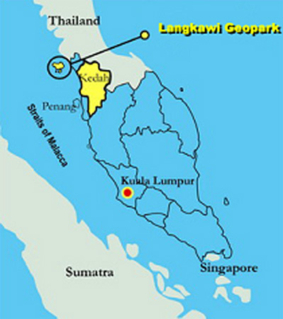
Figure 1. Position of langkawi Geopark in the northwestern corner of Peninsular Malaysia.
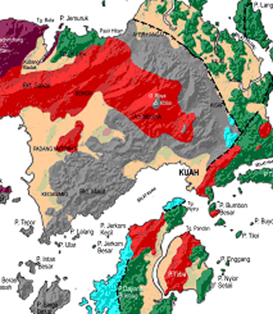
Figure 2. Geological map of Langkawi showing the distribution of various rock formations.
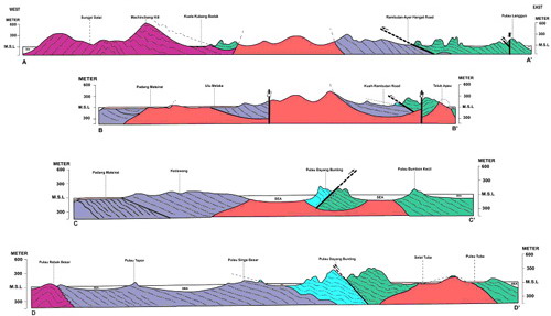
Figure 3. Geological cross-sections showing the general trend of sedimentary deposition and the role of Kisap Thrust Fault and granite intrusion towards the final distribution of various rock formations in the islands - modified after Jones (1981).
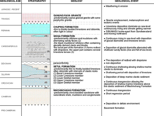
Figure 4. Summary on important Palaeozoic geological history of Langkawi Islands
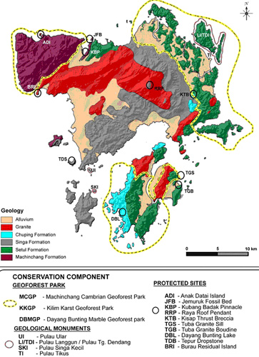
Figure 5. Distribution of Langkawi geoforest parks, geological monuments and some of the protected geosites within Langkawi Geopark.