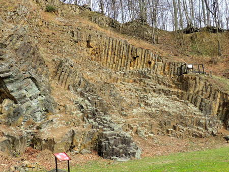
“At first glance, the pillars at Rupnica appear made by man, yet they are the work of a cooling volcano”
Papuk UNESCO Global Geopark is located in Slavonia, in eastern Croatia. The lowland area of Slavonia is mostly flat agricultural landscape while the Slavonian Mountains reach up to nearly 1000 m high. The UNESCO Global Geopark encompasses the whole territory of the Papuk Nature Park, a protected area since 1999. Mt. Papuk is generally spreading out in an East – West direction and abounds with springs and streams. The highest peak is Papuk (953 m). Papuk's ridge presents the watershed between the Drava catchments area (in the north) and the Sava catchments area (in the south).
Papuk is the most prominent of the Slavonian Mountains and shows exceptional geological diversity and complex evolution. Mount Papuk has a “stormy” geological history going as far back as the Precambrian with metamorphic rocks that date back as far as the Pre-Cambrian, more than 540 million years ago. More recent geological features result from mountain building with Mesozoic sediments 260 and 65 million years old, including carbonate rocks, mostly dolomites, numerous karst phenomena like sinkholes, caves, speleothems, caverns, springs etc. as well as the Cretaceous volcanic sedimentary complex of Rupnica which was protected as Croatia’s first natural geological monument in 1948. The Rupnica geosite is famous due to a characteristic exposure of the columnar jointing developed in the al-bite rhyolite volcanic rock. The columnar jointing develops due to the regular fracture system that result from the cooling and crystallization of volcanic mass. Analysis performed on the Rupnica geosite shows mostly four- and five-sided columns. The Cenozoic development of Papuk is closely connected to the Pannonian Basin System evolution, tectonics, volcanism and sedimentation.
Administratively the Papuk UNESCO Global Geopark territory is located in two counties, Požeško-slavonska and Virovitičko-podravska, and is comprised of seven municipalities.
The Geopark offers educational programs for visitors and exhibits remnants such as metal tools, pottery, weapons from prehistoric and medieval times, thus giving a combination of natural and cultural features. The Geopark is a favourite destination for climbing, bike riding, hiking, winter skiing and swimming in warm thermal water. The Geopark strives to ensure that the twin objectives of nature conservation and sustainable development are well balanced and that tourism activities contribute to the sustainable development of this protected area as well as local community. Local development is stimulated through promotion of local products through local fairs or promotional corners in Visitor centres.
Educational activities are one of the main tasks among the UNESCO Global Geopark’s activities. Most of the geosites in Papuk UNESCO Global Geopark have educational value and are used as a school for school children and university students. In order to raise awareness of UNESCO Global Geopark values we regularly entertain local schools and give lectures or perform workshops. Recently we developed an educational project “Rupko’s geological school” where we set up a few educational panels to explain the most important geological features of Papuk UNESCO Global Geopark. More and more locals find their economic interests through cooperation with the Papuk UNESCO Global Geopark.


